The Lower Mississippi River Water Trail

Main Channel (17.5 miles): follow the fastest water down the middle of the river sliding gently towards right bank down to the Loosahatchie Bar then slowly crossing back over to Mud Island for final approach into the Harbor.  Advantages: you’ll get there faster with less paddling, and you won’t have to worry about any surprises like “is the water high enough to get over that dike?”  or “Is that channel going to be blocked by driftwood?”


River Right behind Redman, and Loosahatchie (19.7 miles): Only possible when the river is 15 MG and above.  Stay river right down to Memphis and you will be able to jump behind Lower Brandywine, Redman and Loosahatchie Bars, for a fantastic glimpse of the beauty and wildlife of the back channel, as well as the shade afforded by tall trees along the narrow channels, the protection from the wind on a windy day, and from severe storms on a stormy day.  Warning: if you go back channel Loosahatchie Bar and intend to make a landing in the Mud Island Memphis Harbor, you will have a to execute a high pressure crossing that will require a combination of a long hard paddle and big river know-how.


River Left Behind Hickman (18.2 miles) Possible above 15G, but best done above 20MG.  Stay river left and follow the Tennessee shore downstream along the deep forests of Meeman-Shelby Forest State Park with possible stops on two sand spits with big trees not far behind (see below for more description).  Cut into the first of the Hickman Islands and stay back channel six miles behind six islands.  Keep river right and cut into the mouth of the Loosahatchie for a short detour, continue downstream past Upper Wastewater Treatment Plant, make a quick detour into the Mouth of the Wolf River, and then continue down following along the shore of Mud Island, under the M Bridge and into the Beale Street Harbor.


LBD 749-742 Hickman Bar

https://maps.google.com/maps/ms?msid=217859314001592865582.0004e422a7eddf37b2559&msa=0&ll=
35.269448,-90.084801&spn=0.173228,0.225391

http://goo.gl/maps/hYtXg


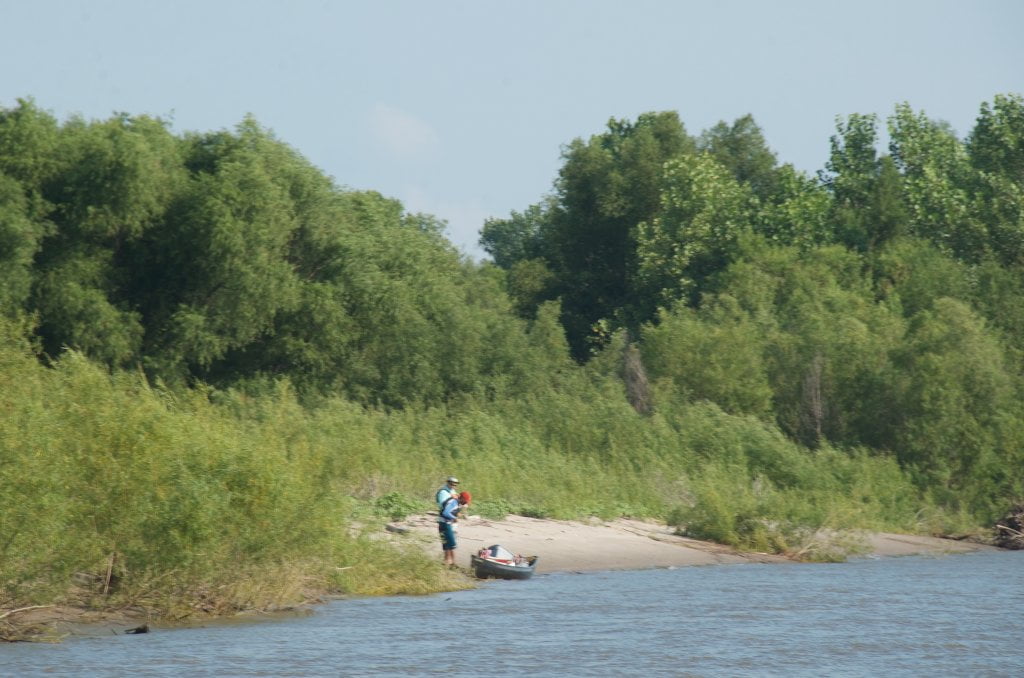
Several long miles downstream of Shelby Forest, after about an hour of paddling, you will encounter the first of a long group of islands hugging the left bank (the Tennessee side of the river).  These are the many islands of the Hickman Bar archipelago.  At or above medium water level (15 MG) the water flows behind the islands and you can turn inwards and enjoy the beauty of the back channel.  The journey is longer and the river is slower, but your appreciation of the river increase many-fold.  You will also enjoy more wildlife and glimpses of big trees and extensive willow forests.  At 15MG there will be some exposed rock along the dikes with shallow crossings and some big drops.  You might scrape your canoe or kayak on some submerged rocks or boulders.  Or even worse, you might run aground and be flipped over.  I’ve had this happen to me one time in a kayak, and I lost everything I had in the cockpit save a watercolor notebook.  It’s best to wait until the river is 20MG and above.  The water speed will be significantly enhance also.  At 25MG there will be good flow throughout, and at 30 a fast flow.  Above flood stage 34MG all islands will be underwater.  

Leave A Comment

SECTION MILE ACCESS CITY
Middle Mississippi & Bluegrass Hills / Bootheel 195-0, 954-850 ST. LOUIS TO CARUTHERSVILLE
Chickasaw Bluffs 850 – 737 CARUTHERSVILLE TO MEMPHIS
Introduction  
Caruthersville to Osceola
850 – 737 LBD Options for Paddlers in the Caruthersville Stretch
Above Caruthersville  
Below Caruthersville  
850 RBD Caruthersville Harbor Boat Ramp (1/2 Mile Up Harbor)
849 RBD Mouth of the Carutherville Harbor
849 RBD Trinity Barge Fabrication Plant
847 RBD Blaker Towhead
846.5 Caruthersville
846 RBD Isle of Capri/Lady Luck Casino and Casino Inn Suites
845 – 840 LBD Caruthersville – Linwood Bend
850 RBD – 840 LBD Day Trip: Caruthersville to Booth’s Point
840 LBD Linwood Bend Boat Ramp
839 Caruthersville Bridge
Bridges and Mud: How Deep is the Mississippi Mud  
Several Routes Around Islands 18, 20 and 21  
838 – 835 LBD Island 18 Towhead
829 – 832 RBD Island 20 Dikes and Towhead
823 – 829 LBD Island 21
Routes for the Paddler Around Tamm/Barfield Bends  
820 – 815 RBD Wright’s Point – Tamm Bend
819.3 LBD Mouth of the Obion River
Moss Island WMA  
817.7 LBD Tamm’s Landing and Ed Jones Boat Ramp
817.7 – 801.8 LBD Chickasaw National Wildlife Refuge
No Levee?  
814 LBD Nebraska Landing
815 – 805 LBD Barfield Bend
809.3 RBD Barfield Boat Ramp
806 RBD Tomato Arkansas
805 – 801 RBD Island 25
Paddler’s Options in the Island 30 – Osceola Area  
800 – 796.5 RBD Island 26 and Forked Deer Island 27
803 – 787 RBD Ashport-Keyes Gold Dust
796 – 791 RBD Ashport Gold Dust Dikes
797 LBD Shoaf Landing
797 LBD Lower Forked Deer River
796 LBD Ashport-Keyes Boat Ramp
793 – 785 RBD Island 30
796 LBD Ashport-Keyes Boat Ramp
Neark (Jacksonville) Landing  
786.5 LBD Back Channel Island 30
785 RBD Osceola Arkansas
783.5 RBD Sans Souci Boat Ramp
Osceola to Shelby Forest
785 RBD Osceola Arkansas
783.5 RBD Sans Souci Boat Ramp
782 LBD Driver Island
779.8 LBD Old Mouth of the Forked Deer
779 – 778 LBD First Chickasaw Bluff
Alternate Paddler’s Route Around Hatchie River & 2nd Chickasaw Bluff  
778 – 773 RBD Sunrise Towhead – Island 34
777 – 773.5 LBD Hatchie Towhead
773.5 LBD Mouth of the Hatchie River
773.5 LBD Lower Hatchie National Wildlife Refugee
771 – 772 LBD Angelo Towhead
771 LBD Randolph Landing
771 – 769 LBD The Second Chickasaw Bluff (Richardson Bluff)
768.9 LBD Richardson’s Landing
768 LBD Randolph’s Landing/Duvall’s Boat Ramp
766 – 763 LBD Below Richardson’s Landing Dikes and Bar
Dyess Arkansas, Birthplace of Johnny Cash’s Five Feet High and Rising  
Five Feet High and Rising  
767.6 – 761.5 RBD Island 35
767 RBD Island 35 Boat Ramp
Back Channels of Island 35  
767.6 RBD Entrance
761.5 RBD Exit Behind Dean Isand
Memphis Gage  
Dikes and Water Levels  
Reading Google Maps  
761.5 – 757 RBD Dean Isand
761.5 – 757 RBD Back Channel of Dean Isand
Third Chickasaw Bluff  
758 – 754 LBD Denseford Bar and Dikes/Hen and Chicks
752.7 LBD Shelby Forest Boat Ramp
Shelby Forest to Memphis
Memphis Gage  
Dikes and Water Levels  
752.7 LBD Shelby Forest Boat Ramp
Hen & Chicks Round Trip  
754 – 745 LBD Meeman Shelby Forest State Park
754 – 747.5 RBD Back Channel of Brandywine Island
Buoys and Dikes  
Paddling Into Memphis: Three Distinct Routes  
749 – 742 LBD Hickman Bar
Picknicking and Camping on Hickman  
746 LBD Upper Hickman
745 LBD Middle Hickman
744 LBD Lower Hickman
743 LBD Below Lower Hickman
740.6 LBD Loosahatchie River
743.5 – 740 LBD Redman Point Bar
Memphis Upper Waswater Treatment Plant  
M.C. Stiles Waterwater Treatment Facility  
739 LBD Conoco Lucy-Woodstock Memphis Chemical Terminal Dock
740.6 LBD Wolf River
738.4 LBD Mud Island Upper Boat Ramp
740 – 737.5 Loosahatchie Bar
737.5 Ferry Crossing to Memphis From the Bottom of Loosahatchie Bar
737 Memphis “M” Bridge (Hernando De Soto Bridge)
736 LBD 4th Chickasaw Bluff: Memphis
736 LBD Memphis Mud Island Harbor
Mud Island Riverpark & Museum  
Memphis Yatch Club Marina & Boat Ramp  
Coast Guard Boat Ramp  
Memphis Conveniences Useful to Paddlers  
Several Challenging Round-trips From Memphis  
The Lossahatchie Redman Figure-Eight  
The Loosahatchie Roundtrip  
Hickman Bar Roundtrip  
Upper Delta 737 – 663 MEMPHIS TO HELENA
Middle Delta 663 – 537 HELENA TO GREENVILLE
Lower Delta 537 – 437 GREENVILLE TO VICKSBURG
Loess Bluffs 437 – 225 VICKSBURG TO BATON ROUGE
Atchafalaya River 159 – 0 SIMMESPORT TO MORGAN CITY
Louisiana Delta 229 – 10 BATON ROUGE TO VENICE
Birdsfoot Delta 10 – 0 VENICE TO GULF OF MEXICO