The Lower Mississippi River Water Trail

Daytrip: St. Francis to Helena

https://maps.google.com/maps/ms?msid=217859314001592865582.0004e5e1cb759adacd604&msa=0&ll=
34.571603,-90.564079&spn=0.209196,0.444603

http://goo.gl/maps/JpRqM


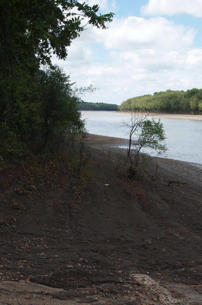
You can make a simple daytrip from the Mouth of the St. Francis to the Helena Harbor.  This 9 mile section of river is appropriate for any Intermediate Paddlers with the usual Big River precautions because you don’t have to make any open channel crossings or get in the middle of towboat traffic.  You can hug the Arkansas Bank all the way Helena — with Arkansas Game & Fish Buck Island halfway down for stopping, stretching, hiking, birding, beach combing, picnicking and camping.  Take-out: Helena Harbor RBD 663.  Water Time: 2-3 hours depending on river speed, wind speed, and your paddling ambitions.   Put in at the St. Francis confluence and canoe downstream alongside the variegated woods that parallel Crowley’s Ridge into Helena. Side-channels and secret waterways to explore depending on river level. Great fossil hunting and bird watching from the gravel bars at the top end of Buck Island. Becoming a habitat for Bald Eagle.


St. Francis to Helena:

Points of Interest along the Way

Mile 0 Mouth of the St. Francis River 672 RBD

Mile 1 St. Francis Towhead Island Bar 671 LBD

Mile 2 Helena Islands 671-669 LBD

Mile 3 The Fawns (Prairie Point Dikes) 669-668 RBD

Mile 4 Flower Lake Dikes 669-667 LBD

Mile 4 Entrance to Buck Island Chute 668 RBD

Mile 5 Buck Island 669-664 RBD

Mile 6 Doe Island 666 RBD

Mile 7 Trotter’s Pass 665.5 LBD

Mile 8 Bottom of Buck Island 664 RBD

Mile 9 Helena Harbor 663


St. Francis to Helena: Paddler’s Descriptions:

A) For Intermediate Paddlers: Right Bank Route

Intro:

The easiest (and safest) daytrip is to enter the main channel and keep a line downstream following the Arkansas shoreline all the way down into Helena.  This is a fairly safe and predictable route because you don’t have to cross the main channel and therefore are not subjected to the dangers of paddling with towboats.  It’s as simple as 1-2-3 “right, right, right!”  i.e.: 1) take a right at the Mississippi and 2) stay right behind the big island, and 3) take a right into the harbor.  However it gets a little more complicated as the river levels change.   For one thing you won’t want to go behind the island if the river is below 25HG.  Stay main channel at low water.  You will have to negotiate a few buoys along the way. 

Leave A Comment

SECTION MILE ACCESS CITY
Middle Mississippi & Bluegrass Hills / Bootheel 195-0, 954-850 ST. LOUIS TO CARUTHERSVILLE
Chickasaw Bluffs 850 – 737 CARUTHERSVILLE TO MEMPHIS
Upper Delta 737 – 663 MEMPHIS TO HELENA
Introduction  
Memphis to Tunica
736 LBD Memphis, Tennessee, Mud Island Harbor
Buoys and Docks  
Floating Underneath a Bridge  
734.7 Lower Bridges/Engineer’s Bar
734.7 The Frisco Bridge
734.7 The Harahan Bridge
734.7 The Ghost Bunker
734.7 The Old Bridge (Memphis & Arkansas Bridge)
733 President’s Island
Fleeted Barges  
732 LBD Hole in the Wall ##2
727.3 TVA Transmission Lines
727.3 RBD The Wreck of the Raft
Tennessee Valley Authority  
725.5 LBD Entrance to McKellar Lake
7 Miles Up harbor Riverside Park Marina On McKellar Lake  
724 T.E. Maxon Wastewater Treatement Facility
Paddler’s Routes Below Memphis  
727 – 712 Dismal Point/Ensley Bar/Cow Island Bend Area
726 – 717 Armstrong/Dismal Point/Ensley Bar
720 Josie Harry Bar
718 – 713 Cow Island Bend
Goodbye Tennessee, Hullo Mississippi  
The Yazoo-Mississippi Delta and the Blues  
711 – 705 Cat Island No.50
710.8 LBD Starr Landing
712 – 695 Paddler’s Routes Around Cat Island and the Casinos
Pickett Dikes Back Channel  
639.8 RBD Tunica Riverpark Museum Boat Ramp
Tunica Riverpark Museum  
Basket Bar Dikes/Porter lake Dikes  
693.8 RBD Lost Lake Pass
703 Buck Island (No. 53)
701 Gold Strike Casino
700 Fitzgerald’s Casino
Tunica to Helena
700 Basket Bar
Paddler’s Routes Through Commerce and Mhoon Bends  
695 – 690 Commerce Bend
692.5 RBD Peter’s Boat Ramp
690 Rabbit Island
Switching to thhe Helena Gage  
Dikes and Water Levels  
687.5 Mhoon Landing
689 – 685 Mhoon Bar
690 – 683 Mhoon Bend
682 – 679 Whiskey Chute/Walnut Bend
680 Whitehall Crevasse
Paddler’s Routes Below Walnut Bend  
Stumpy Island, Shoo Fly Bar and Tunica Lake  
Main Channel  
677.4 LBD Tunica Runout
Behind Shoo Fly Bar  
Stumpy Island  
Walnut Bend Boat Ramp  
Tunica Lake Boat Ramp  
679 RBD Walnut Bend Boat Ramp
679 – 677 Hardin Cut-Off
677.4 LBD Pass Into Tunica Lake
677 – 676 Shoo Fly Bar
677 – 674 Stumpy Island
674.5 Harbert Point
672 RBD Mouth of the St. Francis River
Primitive Landing at the Mouth of the St. Francis Rive – Conditions  
RBD 3 Miles up St. Francis River Three Mile Ramp
Daytrip: St. Francis to Helena  
St. Francis to Helena: Paddler’s Descriptions  
For Intermedite Paddlers: Right Bank Route  
For Expert Paddlers: Left Bank Route  
St. Francis River  
671 – 673 LBD St. Francis Bar
669 LBD Flower Lake Dikes
668 RBD (A View of) Crowley’s Ridge D
668-663 RBD Buck Island (Prairie Point Towhead)
665.5 LBD Trotter’s Pass
663 RBD Helena Harbor
Helena Boat Ramps  
663 RBD Helena-West Helena
Quapaw Canoe Company – Helena Outpost  
Helena’s “Low Road” Into St. Francis National Forest  
King Biscuit Blues Festival (2nd Week of October)  
Helena to Friars
661.6 Helena Bridge (Hernando De Soto Bridge – US HWY 49)
663 RBD Leaving Helena Harbor
Fleeted Barges  
Small Towns in Harbors  
Buoys and Other Stationary Objects  
Highlights of Civilization  
Pollution Within the Helena Industrial Reach  
661.6 Helena Bridge (Hernando De Soto Bridge – US HWY 49)
657 LBD  
How to Get Into the Old Entrance of the Yazoo Pass  
LBD: Alternate Route to Vicksburg: Yazoo Pass  
Yazoo Pass Milage  
Rivers & Robert Johnson  
656 LBD East Montezuma Bar
657 – 654 RBD Montezuma Towhead
654.7 LBD Montezuma Landing
Shuttle Route Montezuma to Clarksdale  
652 LBD Friars Point
652.2 LBD Friars Point Landing (Unimproved)
What’s to Come Further Downstream  
Appendix  
Middle Delta 663 – 537 HELENA TO GREENVILLE
Lower Delta 537 – 437 GREENVILLE TO VICKSBURG
Loess Bluffs 437 – 225 VICKSBURG TO BATON ROUGE
Atchafalaya River 159 – 0 SIMMESPORT TO MORGAN CITY
Louisiana Delta 229 – 10 BATON ROUGE TO VENICE
Birdsfoot Delta 10 – 0 VENICE TO GULF OF MEXICO