The Lower Mississippi River Water Trail
We should have died after wrecking our raft in February 1983. I wasn’t wearing neoprene like I do now in cold water. The wreck threw us in the river, Sean on one side of the pylon and me on the other, we popped up and called out to each other, “Sean! Sean!”, “Here I am Johnnie!” We pulled pieces of wreckage together and tied it best we could with our ropes. My guitar was floating close by so I pulled it in. A daypack with some essentials that later helped lead to our rescue. We saved some frozen chickens we had bought that morning in Memphis. We heaved ourselves as far as we could out of the numbing currents, which meant getting our chests on one of the barrels, which kept flopping and twisting in the boils and eddies of the main channel and we floated past a mid-channel bunch of islands along the appropriately-named Dismal Point Dikes. A low ceiling of grey-blue clouds with feathered edges had slid in and now covered the sky and the wind was gently moving out of the north. Everything was peaceful after the drama of the day. We swirled around Cow Island Bend and into the State of Mississippi where a spectacular land mass called Cat Island divides the river in two like a blunt sword. We were reaching the end of our physical abilities to stay warm. We no longer felt cold. It would have been so easy to let go and just float away into the liquid hands of the mother river, and if we had at that point it would have been painless and pleasant. The void awaited us as closely as the skies above and the river below. Sunset was approaching. The river gurgled along smooth and unperturbed. We were both at the weakest and possibly the lowest points of our lives, barely hanging on by a soggy thread. I’ve never shared this in such detail before today, but it seems now that I had reached a state of some kind of fluid nirvana. Everything was gone that I had previously known and had sustained me, except for the wreckage of the raft, and I was ready to let it go. It was that easy. I could have let go then and died peacefully, and without regrets.
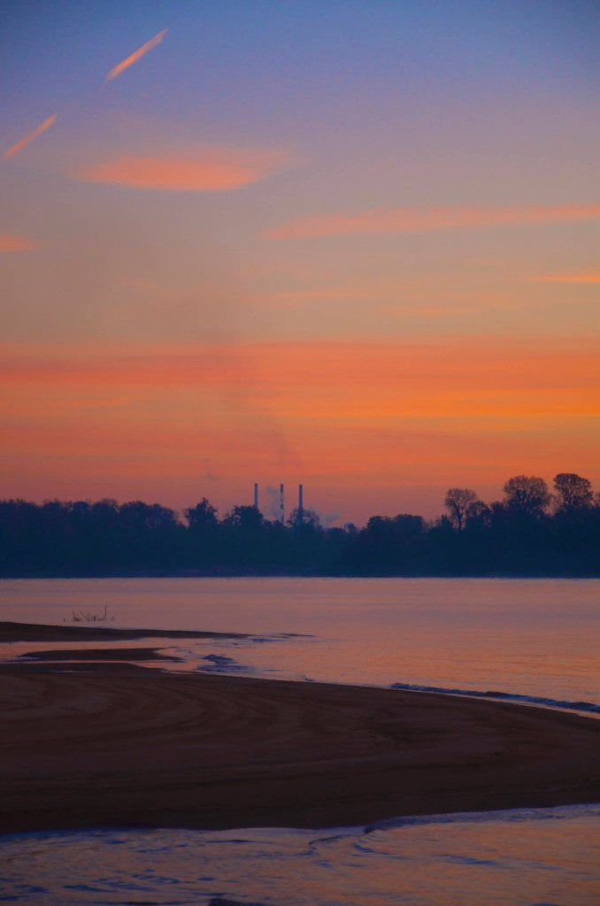
But then the sun descended below the cloudy ceiling. A last stream of sunshine edged out underneath the grey mass, gathered strength, and then glistened outwards from over the extensive Arkansas floodplain to our west and bathed Cat Island and the endless forests of Mississippi in a wedge of yellowness. And as the wonders of Cat Island grew bigger downstream, a brilliant sense of beauty and harmony hit me with this last ray of warm yellow sunshine and jolted me out of my coma. It was the mystery and beauty of the earthly elements of this mid-continent wilderness, illuminated now by the low angle February light that filled the Mississippi Valley and flooded the Cow Island Bend with glorious array that shocked me alive and ignited in me a tiny spark of purpose. We were illuminated with the same streaming amber light and I gazed at Sean’s face and our surroundings in wonder, and it felt like we had entered the land of milk and honey. The noise and pollution of Memphis and the TVA tower and the crackling power lines and the terror of the crash and swirling cold waters were all a distant memory. All that remained was Sean and the river, the woods and the sky. It seemed too good to be true. If there is a heaven I am sure we found it. But I was troubled by two thoughts. The first came to me as I gazed downstream upon the sands and forests of Cat Island now softly glowing against the cobalt blue sky by the setting sun. I found myself wondering what it would be like to walk across the island and imagining what secret places were there contained within the sandy undulations and pristine pockets of willows, cottonwoods, sycamores and sweetgums and oaks. The sand looked so soft and warm and inviting. It looked dry. I could see flocks of birds darkening the edges of the forest where they met the water, probably red-winged blackbirds settling down for the day. And as my curiosity about Cat Island grew so did my troubled mind that I might not ever be able to explore this place of beauty. My feet yearned to touch those soft dry sands. The other thought that troubled me was Sean’s baby-faced innocence, also glowing in the last light of the day, peaceful and angelic. I realized that he had reached the same state of bliss that I had. I could easily let it all go at this moment and die peacefully. But I couldn’t let him die. He was simply too beautiful to let go to waste.

Leave A Comment
You must be logged in to post a comment.