The Lower Mississippi River Water Trail

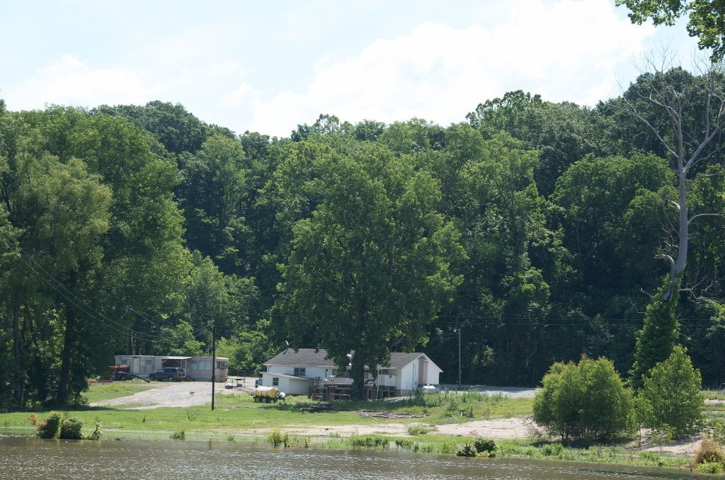
LBD 771 Randolph Landing

Directly behind Angelo Towhead is the tiny bluff town of Randolph, which features a bar, a church, and several houses.  Poor Randolph, at one time it was the favored location for the major port and city of the area, later superseded by its lowly neighbor to the south that become the City of Memphis.  A towering white cross was erected atop its green fields several years ago.  A convenience store is located several miles up the Randolph Road, but nor recommended except in emergency.  There is a primitive landing below this bar, where an access road dead ends at the river bank, but the landing only functional at higher water levels.  Long distance paddlers beware: You can refill you water bottles and buy beer at John’s Boat Dock, which is conveniently located at the top of the boat launch.  But be ready for some classic southern small town curiosity “you ain’t from here are ya?” which might dissolve into hostility depending on the color of your skin, the time of night, and how many beers have been downed before your arrival.  If you’re black, or any other ethnicity, don’t bother stopping at all.  You will most certainly be offended by some of the awful signage in this redneck hangout.  Don’t camp anywhere nearby.  You won’t want to be anywhere close by after dark.  Lots of good choices further downstream.  Best bet if you need to resupply: keep going on to Memphis.


LBD 771-769 The Second Chickasaw Bluff (Richardson Bluff)

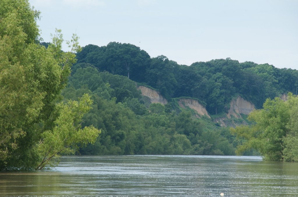
As you paddle along the Hatchie Bar and then past the mouth of the Hatchie River you will be afforded your first vista of the second natural wonder along this section of river, the 2nd Chickasaw Bluff, sometimes known as Richardson Bluff.  Gaze downstream over your vessel towards the towering loess cliffs.  It’s a little deceptive because of the great distances and the scale of the river.  But you will probably be impressed by how much of your vision they fill.  Even at five miles away The 2nd Chickasaw Bluff covers 180 degrees of the horizon!


At first they are nothing more than a reddish brown line of convoluted earth strung across the river, rising slightly above the blue reflections on the muddy water and over the forested islands.  But as you approach nearer they gain height and girth, with towering ridges that look like rock (but are actually mud) and deep fissures.  For an unsuspecting paddler it’s something like driving across the Great Plains and seeing for the first time the Front Range of the Rocky Mountains rising heavenward.  For a floodplain resident who has never witnessed the bluffs in their raw state you might experience vertigo.  You will be filled with a strange feeling of not knowing where the heck you are, so foreign is the landscape.  The bluffs keep growing and growing until you reach their base where they fill most of the southern sky in a roiling collision of colorful earth-tones, mostly yellows, oranges and reds, but some greens, greys and blues also, that collapse in chaotic sequences of horizontal layers and vertical precipices.  With colors of the canyonlands and the texture of Iceland, it’s something like Utah meets Alaska, the topography reminiscent of a colorful calving glacier at the ocean’s terminus, replete with deep crevasses and deep dark earth cracks that seem to flow in a jumbled course from the distinct razor sharp line at the top of the bluff down through many layers of earth and spilling with gravity to the river’s edge.  Adding to the thrill of this exotic atmosphere is a thick kudzu jungle that covers much of the cliffside wherever it has been able to gain a perch, but also where it has consumed whole trees, filled shallow valleys, and created a green kingdom that could have come right out of the Tolkein’s Middle Earth.  A notable scene is kudzu eating the Randolph Light day marker at mile 770.1.

Leave A Comment

SECTION MILE ACCESS CITY
Middle Mississippi & Bluegrass Hills / Bootheel 195-0, 954-850 ST. LOUIS TO CARUTHERSVILLE
Chickasaw Bluffs 850 – 737 CARUTHERSVILLE TO MEMPHIS
Introduction  
Caruthersville to Osceola
850 – 737 LBD Options for Paddlers in the Caruthersville Stretch
Above Caruthersville  
Below Caruthersville  
850 RBD Caruthersville Harbor Boat Ramp (1/2 Mile Up Harbor)
849 RBD Mouth of the Carutherville Harbor
849 RBD Trinity Barge Fabrication Plant
847 RBD Blaker Towhead
846.5 Caruthersville
846 RBD Isle of Capri/Lady Luck Casino and Casino Inn Suites
845 – 840 LBD Caruthersville – Linwood Bend
850 RBD – 840 LBD Day Trip: Caruthersville to Booth’s Point
840 LBD Linwood Bend Boat Ramp
839 Caruthersville Bridge
Bridges and Mud: How Deep is the Mississippi Mud  
Several Routes Around Islands 18, 20 and 21  
838 – 835 LBD Island 18 Towhead
829 – 832 RBD Island 20 Dikes and Towhead
823 – 829 LBD Island 21
Routes for the Paddler Around Tamm/Barfield Bends  
820 – 815 RBD Wright’s Point – Tamm Bend
819.3 LBD Mouth of the Obion River
Moss Island WMA  
817.7 LBD Tamm’s Landing and Ed Jones Boat Ramp
817.7 – 801.8 LBD Chickasaw National Wildlife Refuge
No Levee?  
814 LBD Nebraska Landing
815 – 805 LBD Barfield Bend
809.3 RBD Barfield Boat Ramp
806 RBD Tomato Arkansas
805 – 801 RBD Island 25
Paddler’s Options in the Island 30 – Osceola Area  
800 – 796.5 RBD Island 26 and Forked Deer Island 27
803 – 787 RBD Ashport-Keyes Gold Dust
796 – 791 RBD Ashport Gold Dust Dikes
797 LBD Shoaf Landing
797 LBD Lower Forked Deer River
796 LBD Ashport-Keyes Boat Ramp
793 – 785 RBD Island 30
796 LBD Ashport-Keyes Boat Ramp
Neark (Jacksonville) Landing  
786.5 LBD Back Channel Island 30
785 RBD Osceola Arkansas
783.5 RBD Sans Souci Boat Ramp
Osceola to Shelby Forest
785 RBD Osceola Arkansas
783.5 RBD Sans Souci Boat Ramp
782 LBD Driver Island
779.8 LBD Old Mouth of the Forked Deer
779 – 778 LBD First Chickasaw Bluff
Alternate Paddler’s Route Around Hatchie River & 2nd Chickasaw Bluff  
778 – 773 RBD Sunrise Towhead – Island 34
777 – 773.5 LBD Hatchie Towhead
773.5 LBD Mouth of the Hatchie River
773.5 LBD Lower Hatchie National Wildlife Refugee
771 – 772 LBD Angelo Towhead
771 LBD Randolph Landing
771 – 769 LBD The Second Chickasaw Bluff (Richardson Bluff)
768.9 LBD Richardson’s Landing
768 LBD Randolph’s Landing/Duvall’s Boat Ramp
766 – 763 LBD Below Richardson’s Landing Dikes and Bar
Dyess Arkansas, Birthplace of Johnny Cash’s Five Feet High and Rising  
Five Feet High and Rising  
767.6 – 761.5 RBD Island 35
767 RBD Island 35 Boat Ramp
Back Channels of Island 35  
767.6 RBD Entrance
761.5 RBD Exit Behind Dean Isand
Memphis Gage  
Dikes and Water Levels  
Reading Google Maps  
761.5 – 757 RBD Dean Isand
761.5 – 757 RBD Back Channel of Dean Isand
Third Chickasaw Bluff  
758 – 754 LBD Denseford Bar and Dikes/Hen and Chicks
752.7 LBD Shelby Forest Boat Ramp
Shelby Forest to Memphis
Memphis Gage  
Dikes and Water Levels  
752.7 LBD Shelby Forest Boat Ramp
Hen & Chicks Round Trip  
754 – 745 LBD Meeman Shelby Forest State Park
754 – 747.5 RBD Back Channel of Brandywine Island
Buoys and Dikes  
Paddling Into Memphis: Three Distinct Routes  
749 – 742 LBD Hickman Bar
Picknicking and Camping on Hickman  
746 LBD Upper Hickman
745 LBD Middle Hickman
744 LBD Lower Hickman
743 LBD Below Lower Hickman
740.6 LBD Loosahatchie River
743.5 – 740 LBD Redman Point Bar
Memphis Upper Waswater Treatment Plant  
M.C. Stiles Waterwater Treatment Facility  
739 LBD Conoco Lucy-Woodstock Memphis Chemical Terminal Dock
740.6 LBD Wolf River
738.4 LBD Mud Island Upper Boat Ramp
740 – 737.5 Loosahatchie Bar
737.5 Ferry Crossing to Memphis From the Bottom of Loosahatchie Bar
737 Memphis “M” Bridge (Hernando De Soto Bridge)
736 LBD 4th Chickasaw Bluff: Memphis
736 LBD Memphis Mud Island Harbor
Mud Island Riverpark & Museum  
Memphis Yatch Club Marina & Boat Ramp  
Coast Guard Boat Ramp  
Memphis Conveniences Useful to Paddlers  
Several Challenging Round-trips From Memphis  
The Lossahatchie Redman Figure-Eight  
The Loosahatchie Roundtrip  
Hickman Bar Roundtrip  
Upper Delta 737 – 663 MEMPHIS TO HELENA
Middle Delta 663 – 537 HELENA TO GREENVILLE
Lower Delta 537 – 437 GREENVILLE TO VICKSBURG
Loess Bluffs 437 – 225 VICKSBURG TO BATON ROUGE
Atchafalaya River 159 – 0 SIMMESPORT TO MORGAN CITY
Louisiana Delta 229 – 10 BATON ROUGE TO VENICE
Birdsfoot Delta 10 – 0 VENICE TO GULF OF MEXICO