The Lower Mississippi River Water Trail

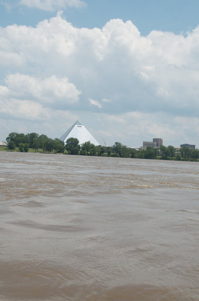
This landing makes for an good take out, if you ignore the smells.  It’s the easiest place to make a Memphis take-out because you the landing is easy to identify from the river, and it will be easy for your pick up party to meet you here.   Big Parking lot at edge of Greenbelt Park in front of Harbor Town.  But you will miss the excitement of paddling under the stately M Bridge, as well as the thrill of arriving in the big city with the unforgettable view of downtown Memphis from the Beale Street Harbor.   Please note that in extreme low water conditions the you might encounter the American Queen docked at Upper Mud Island Landing.  Unsuspecting canoes/kayaks might be surprised to find their once open landing to be covered by this monster of all steamboats!  Normally you can find a way to sneak under the prow of the docked American Queen, but do so with utmost care, and make sure she is firmly tied down, and there are no currents which might cause you trouble.


If you are continuing on into Memphis keep left bank descending and enjoy the long grassy Greenbelt Park with its stately cottonwoods, and the lively scene of families, kids, joggers, bicyclers, picnickers, people reading books and taking naps and people flying kites along the way.  Your best route is the same, stay river left (fastest water).  No tow will come in this close.  Keep to the same under bridge and read below for suggestions for final entry into the Memphis Mud Island Harbor.


740-737.5 Loosahatchie Bar

Loosahatchie Back Channel receives all of the water out of Redman Back Channel — plus a much bigger flow that comes directly from the main channel of the big river.  There is a plug dike at the bottom of Redman Back Channel and a lower island.  You can go to either side of the island, but the easiest route is straight down and over the dike, past the little island, and jump into the Loosahatchie Back Channel.  Thanks to the above mentioned LMRCC the lower dike is also notched, so that there will be flow even at medium water when the rest of the dike is exposed.  When the river is 10-15MG point your canoe towards the v-line and paddle hard through the fast waters pouring through the notch and enjoy the thrill of the resulting waves!


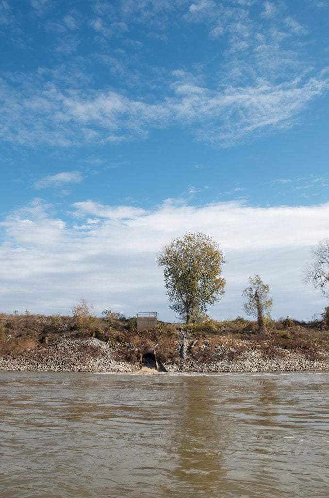
Loosahatchie Back Channel cuts off in low water, now with notching around 5MG.  At low water giant sandbars are found top end with endless possibilities for picnicking, hiking and swimming.  At medium water there is ample flow through the back channel so that you can make it an easy hour long paddle top to bottom.  At high water you could cut that time in half, but why hurry?  The point is to enjoy it, not rush through it like you’re driving down Poplar Avenue to get to an appointment.  And there is plenty to enjoy.  A mile down on river right, the Arkansas bank opens up into an extensive flooded wetlands, open at 20MG, with large pools full of fish and amphibians, flooded grasslands and flooded forests at high water.  Publicly owned Loosahatchie Bar is uninhabited, so you can stop anywhere to explore the forests, which appear unbroken from the river, but once you walk anywhere you discover small prairies, narrow depressions where water runs at flood stage, deep woods, open woods, viney woods, willow forests, stands of cottonwoods, sycamores, sweetgums, and other mature hardwood.  Carry a compass and watch for poison ivy and wild boar.


The three mile long Loosahatchie Back Channel creates one of those urban river anomalies.  You know you’re near a city for all of the jets overhead and vague rumbling and humming from over the trees.  But you and the bald eagle you just witnessed snatching a soft-shell turtle off the sandbar could really care less.  You could spend all day here, not one mile from Harbor Town, not three miles from downtown Memphis, and not see anyone.  You could camp here, and certainly you’d see the glowing lights and smell the caustic smells, but otherwise you would have no idea that you’re camped amidst the tentacles of the biggest city along the last thousand miles of the biggest river on this continent!  I call this “the river illusion.”  

Leave A Comment

SECTION MILE ACCESS CITY
Middle Mississippi & Bluegrass Hills / Bootheel 195-0, 954-850 ST. LOUIS TO CARUTHERSVILLE
Chickasaw Bluffs 850 – 737 CARUTHERSVILLE TO MEMPHIS
Introduction  
Caruthersville to Osceola
850 – 737 LBD Options for Paddlers in the Caruthersville Stretch
Above Caruthersville  
Below Caruthersville  
850 RBD Caruthersville Harbor Boat Ramp (1/2 Mile Up Harbor)
849 RBD Mouth of the Carutherville Harbor
849 RBD Trinity Barge Fabrication Plant
847 RBD Blaker Towhead
846.5 Caruthersville
846 RBD Isle of Capri/Lady Luck Casino and Casino Inn Suites
845 – 840 LBD Caruthersville – Linwood Bend
850 RBD – 840 LBD Day Trip: Caruthersville to Booth’s Point
840 LBD Linwood Bend Boat Ramp
839 Caruthersville Bridge
Bridges and Mud: How Deep is the Mississippi Mud  
Several Routes Around Islands 18, 20 and 21  
838 – 835 LBD Island 18 Towhead
829 – 832 RBD Island 20 Dikes and Towhead
823 – 829 LBD Island 21
Routes for the Paddler Around Tamm/Barfield Bends  
820 – 815 RBD Wright’s Point – Tamm Bend
819.3 LBD Mouth of the Obion River
Moss Island WMA  
817.7 LBD Tamm’s Landing and Ed Jones Boat Ramp
817.7 – 801.8 LBD Chickasaw National Wildlife Refuge
No Levee?  
814 LBD Nebraska Landing
815 – 805 LBD Barfield Bend
809.3 RBD Barfield Boat Ramp
806 RBD Tomato Arkansas
805 – 801 RBD Island 25
Paddler’s Options in the Island 30 – Osceola Area  
800 – 796.5 RBD Island 26 and Forked Deer Island 27
803 – 787 RBD Ashport-Keyes Gold Dust
796 – 791 RBD Ashport Gold Dust Dikes
797 LBD Shoaf Landing
797 LBD Lower Forked Deer River
796 LBD Ashport-Keyes Boat Ramp
793 – 785 RBD Island 30
796 LBD Ashport-Keyes Boat Ramp
Neark (Jacksonville) Landing  
786.5 LBD Back Channel Island 30
785 RBD Osceola Arkansas
783.5 RBD Sans Souci Boat Ramp
Osceola to Shelby Forest
785 RBD Osceola Arkansas
783.5 RBD Sans Souci Boat Ramp
782 LBD Driver Island
779.8 LBD Old Mouth of the Forked Deer
779 – 778 LBD First Chickasaw Bluff
Alternate Paddler’s Route Around Hatchie River & 2nd Chickasaw Bluff  
778 – 773 RBD Sunrise Towhead – Island 34
777 – 773.5 LBD Hatchie Towhead
773.5 LBD Mouth of the Hatchie River
773.5 LBD Lower Hatchie National Wildlife Refugee
771 – 772 LBD Angelo Towhead
771 LBD Randolph Landing
771 – 769 LBD The Second Chickasaw Bluff (Richardson Bluff)
768.9 LBD Richardson’s Landing
768 LBD Randolph’s Landing/Duvall’s Boat Ramp
766 – 763 LBD Below Richardson’s Landing Dikes and Bar
Dyess Arkansas, Birthplace of Johnny Cash’s Five Feet High and Rising  
Five Feet High and Rising  
767.6 – 761.5 RBD Island 35
767 RBD Island 35 Boat Ramp
Back Channels of Island 35  
767.6 RBD Entrance
761.5 RBD Exit Behind Dean Isand
Memphis Gage  
Dikes and Water Levels  
Reading Google Maps  
761.5 – 757 RBD Dean Isand
761.5 – 757 RBD Back Channel of Dean Isand
Third Chickasaw Bluff  
758 – 754 LBD Denseford Bar and Dikes/Hen and Chicks
752.7 LBD Shelby Forest Boat Ramp
Shelby Forest to Memphis
Memphis Gage  
Dikes and Water Levels  
752.7 LBD Shelby Forest Boat Ramp
Hen & Chicks Round Trip  
754 – 745 LBD Meeman Shelby Forest State Park
754 – 747.5 RBD Back Channel of Brandywine Island
Buoys and Dikes  
Paddling Into Memphis: Three Distinct Routes  
749 – 742 LBD Hickman Bar
Picknicking and Camping on Hickman  
746 LBD Upper Hickman
745 LBD Middle Hickman
744 LBD Lower Hickman
743 LBD Below Lower Hickman
740.6 LBD Loosahatchie River
743.5 – 740 LBD Redman Point Bar
Memphis Upper Waswater Treatment Plant  
M.C. Stiles Waterwater Treatment Facility  
739 LBD Conoco Lucy-Woodstock Memphis Chemical Terminal Dock
740.6 LBD Wolf River
738.4 LBD Mud Island Upper Boat Ramp
740 – 737.5 Loosahatchie Bar
737.5 Ferry Crossing to Memphis From the Bottom of Loosahatchie Bar
737 Memphis “M” Bridge (Hernando De Soto Bridge)
736 LBD 4th Chickasaw Bluff: Memphis
736 LBD Memphis Mud Island Harbor
Mud Island Riverpark & Museum  
Memphis Yatch Club Marina & Boat Ramp  
Coast Guard Boat Ramp  
Memphis Conveniences Useful to Paddlers  
Several Challenging Round-trips From Memphis  
The Lossahatchie Redman Figure-Eight  
The Loosahatchie Roundtrip  
Hickman Bar Roundtrip  
Upper Delta 737 – 663 MEMPHIS TO HELENA
Middle Delta 663 – 537 HELENA TO GREENVILLE
Lower Delta 537 – 437 GREENVILLE TO VICKSBURG
Loess Bluffs 437 – 225 VICKSBURG TO BATON ROUGE
Atchafalaya River 159 – 0 SIMMESPORT TO MORGAN CITY
Louisiana Delta 229 – 10 BATON ROUGE TO VENICE
Birdsfoot Delta 10 – 0 VENICE TO GULF OF MEXICO