The Lower Mississippi River Water Trail

LBD 773.5 Mouth of the Hatchie River

The Hatchie River is the biggest volume river of all West Tennessee tributaries, partly due to the fact that it alone was never dredged, straightened, or otherwise channelized.  The Wolf, The Loosahatchie, the Obion, and the Forked Deer – all are suffering from the overzealous engineering of the last century with poor water quality and lower levels of water flow.  The lesson is crystal clear: take a river away from its wetlands and the water quality and quantity will be diminished.  Not surprisingly, the Hatchie is also the only West Tennessee river designated as a wild & scenic river under the Tennessee Wild and Scenic Rivers Act.


Hatchie literally means “river” in the Chickasaw tongue, as well as Cherokee, which explains its reoccurrence throughout the Southeast, in famous rivers like Billy Joe McAllister’s Tallahatchie, and less famous ones such as the Loosahatchie.


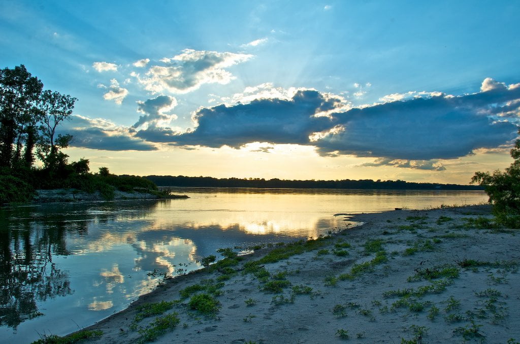
The Hatchie River springs out of northern Mississippi and meanders northerly, then northwesterly and then finally westerly to the mother river, the Mississippi, through extensive bottomland wetlands several miles wide.  There is always good water flow on the lower Hatchie, especially in the last 30 miles or so below the Highway 51 Bridge.  


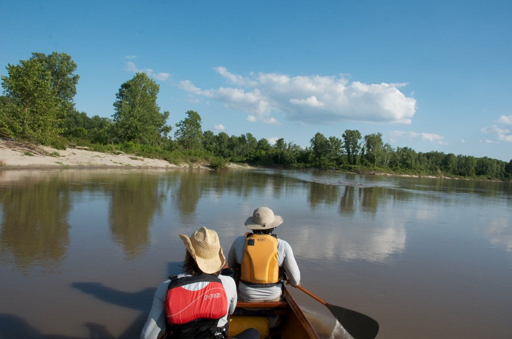
As such, canoeists and kayakers are afforded a fantastic opportunity to paddle out of this tree-lined, narrow, wild & scenic river full of fish, amphibians, birds, other wildlife and deep woods, through its bottomland hardwood forests, alongside many of its swamps and adjacent wetlands, right through its final willow/cottonwood forests and into its confluence with the Mississippi.  Put in at either the 51 Bridge (Hatchie River mile 30) or the Club Road Landing (Hatchie River mile 7).  Paddle downstream to the mouth of the Mississippi, and then continue downstream for takeout at Duvall Landing (5 miles on the Mississippi), Meeman Shelby State Park (21 miles) or Mud Island Memphis (38 miles).


A first time paddler on the Mississippi leaving the Hatchie described it as follows, with the delightful fresh language of a newbie:


“I was expecting a fast moving and turbulent river, but what I saw was as smooth as glass. My heart was pounding, but I didn’t know why. I felt very small and that I was entering something very big. As I eased out into the smooth water, it seemed to be breathing, rising and falling with a motion that I could plainly feel, yet I could not really see any motion on the surface of the water.  There was no barge traffic in sight, and I knew I needed to cross immediately to  carry out my plan of keep to the sandy side. There was nothing to do but paddle like hell for the other side. The surface before me stayed glassy, yet I could plainly see water was rising to the surface from below, which caused circular tables to form and then immediately fade away. My heart would not stop pounding, and it was not from the exertion. My paddle strokes were strong from adrenaline and very soon I landed on the far shore…”

 (from the Iconoclast: Drive By Life)

Leave A Comment

SECTION MILE ACCESS CITY
Middle Mississippi & Bluegrass Hills / Bootheel 195-0, 954-850 ST. LOUIS TO CARUTHERSVILLE
Chickasaw Bluffs 850 – 737 CARUTHERSVILLE TO MEMPHIS
Introduction  
Caruthersville to Osceola
850 – 737 LBD Options for Paddlers in the Caruthersville Stretch
Above Caruthersville  
Below Caruthersville  
850 RBD Caruthersville Harbor Boat Ramp (1/2 Mile Up Harbor)
849 RBD Mouth of the Carutherville Harbor
849 RBD Trinity Barge Fabrication Plant
847 RBD Blaker Towhead
846.5 Caruthersville
846 RBD Isle of Capri/Lady Luck Casino and Casino Inn Suites
845 – 840 LBD Caruthersville – Linwood Bend
850 RBD – 840 LBD Day Trip: Caruthersville to Booth’s Point
840 LBD Linwood Bend Boat Ramp
839 Caruthersville Bridge
Bridges and Mud: How Deep is the Mississippi Mud  
Several Routes Around Islands 18, 20 and 21  
838 – 835 LBD Island 18 Towhead
829 – 832 RBD Island 20 Dikes and Towhead
823 – 829 LBD Island 21
Routes for the Paddler Around Tamm/Barfield Bends  
820 – 815 RBD Wright’s Point – Tamm Bend
819.3 LBD Mouth of the Obion River
Moss Island WMA  
817.7 LBD Tamm’s Landing and Ed Jones Boat Ramp
817.7 – 801.8 LBD Chickasaw National Wildlife Refuge
No Levee?  
814 LBD Nebraska Landing
815 – 805 LBD Barfield Bend
809.3 RBD Barfield Boat Ramp
806 RBD Tomato Arkansas
805 – 801 RBD Island 25
Paddler’s Options in the Island 30 – Osceola Area  
800 – 796.5 RBD Island 26 and Forked Deer Island 27
803 – 787 RBD Ashport-Keyes Gold Dust
796 – 791 RBD Ashport Gold Dust Dikes
797 LBD Shoaf Landing
797 LBD Lower Forked Deer River
796 LBD Ashport-Keyes Boat Ramp
793 – 785 RBD Island 30
796 LBD Ashport-Keyes Boat Ramp
Neark (Jacksonville) Landing  
786.5 LBD Back Channel Island 30
785 RBD Osceola Arkansas
783.5 RBD Sans Souci Boat Ramp
Osceola to Shelby Forest
785 RBD Osceola Arkansas
783.5 RBD Sans Souci Boat Ramp
782 LBD Driver Island
779.8 LBD Old Mouth of the Forked Deer
779 – 778 LBD First Chickasaw Bluff
Alternate Paddler’s Route Around Hatchie River & 2nd Chickasaw Bluff  
778 – 773 RBD Sunrise Towhead – Island 34
777 – 773.5 LBD Hatchie Towhead
773.5 LBD Mouth of the Hatchie River
773.5 LBD Lower Hatchie National Wildlife Refugee
771 – 772 LBD Angelo Towhead
771 LBD Randolph Landing
771 – 769 LBD The Second Chickasaw Bluff (Richardson Bluff)
768.9 LBD Richardson’s Landing
768 LBD Randolph’s Landing/Duvall’s Boat Ramp
766 – 763 LBD Below Richardson’s Landing Dikes and Bar
Dyess Arkansas, Birthplace of Johnny Cash’s Five Feet High and Rising  
Five Feet High and Rising  
767.6 – 761.5 RBD Island 35
767 RBD Island 35 Boat Ramp
Back Channels of Island 35  
767.6 RBD Entrance
761.5 RBD Exit Behind Dean Isand
Memphis Gage  
Dikes and Water Levels  
Reading Google Maps  
761.5 – 757 RBD Dean Isand
761.5 – 757 RBD Back Channel of Dean Isand
Third Chickasaw Bluff  
758 – 754 LBD Denseford Bar and Dikes/Hen and Chicks
752.7 LBD Shelby Forest Boat Ramp
Shelby Forest to Memphis
Memphis Gage  
Dikes and Water Levels  
752.7 LBD Shelby Forest Boat Ramp
Hen & Chicks Round Trip  
754 – 745 LBD Meeman Shelby Forest State Park
754 – 747.5 RBD Back Channel of Brandywine Island
Buoys and Dikes  
Paddling Into Memphis: Three Distinct Routes  
749 – 742 LBD Hickman Bar
Picknicking and Camping on Hickman  
746 LBD Upper Hickman
745 LBD Middle Hickman
744 LBD Lower Hickman
743 LBD Below Lower Hickman
740.6 LBD Loosahatchie River
743.5 – 740 LBD Redman Point Bar
Memphis Upper Waswater Treatment Plant  
M.C. Stiles Waterwater Treatment Facility  
739 LBD Conoco Lucy-Woodstock Memphis Chemical Terminal Dock
740.6 LBD Wolf River
738.4 LBD Mud Island Upper Boat Ramp
740 – 737.5 Loosahatchie Bar
737.5 Ferry Crossing to Memphis From the Bottom of Loosahatchie Bar
737 Memphis “M” Bridge (Hernando De Soto Bridge)
736 LBD 4th Chickasaw Bluff: Memphis
736 LBD Memphis Mud Island Harbor
Mud Island Riverpark & Museum  
Memphis Yatch Club Marina & Boat Ramp  
Coast Guard Boat Ramp  
Memphis Conveniences Useful to Paddlers  
Several Challenging Round-trips From Memphis  
The Lossahatchie Redman Figure-Eight  
The Loosahatchie Roundtrip  
Hickman Bar Roundtrip  
Upper Delta 737 – 663 MEMPHIS TO HELENA
Middle Delta 663 – 537 HELENA TO GREENVILLE
Lower Delta 537 – 437 GREENVILLE TO VICKSBURG
Loess Bluffs 437 – 225 VICKSBURG TO BATON ROUGE
Atchafalaya River 159 – 0 SIMMESPORT TO MORGAN CITY
Louisiana Delta 229 – 10 BATON ROUGE TO VENICE
Birdsfoot Delta 10 – 0 VENICE TO GULF OF MEXICO