The Lower Mississippi River Water Trail

So, you’ve started your crossing from the dike below Loosahatchie Bar: you’ve got a good angle, you can feel yourself slipping a little watching the trees on opposite shore, but not too much.  You are fairly comfortable you will reach Mud Island above the bridge.  Now it’s just a matter of hard paddling.  Pick a stroke you can maintain for 20 minutes or less and keep the rhythm.  The boils that emanate upwards mid-channel can help you.  If possible stay to the upstream side of any boils that erupt and they will actually push you slightly upstream and make your crossing easier.  If you paddle by them on their downstream side they will make things harder by pushing you downstream.  I like to make a game of it, it’s a real-life video game, a real-time pinball game. Every move you make is effected by the immediate motions of the river around you and your response to them.


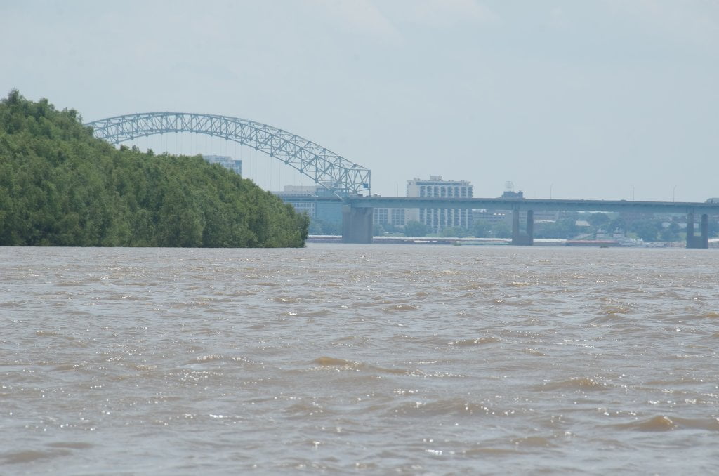
After you’ve crossed 95% of the channel, Mud Island is maybe 100 yards away, and you are still above the bridge.  You can relax a little, and slacken your pace.  Bravo!  You made it across.  The worst is over.  It’s time to turn downstream and follow the currents under the bridge and past Mud Island River Park and look for the Harbor opening just below on river left.   Stay in the fast water unless there is a tow coming upstream close to you.  If you get too close to the Mud Island shore you will hit the slow water, the boils, and the eddies.  There are several eddies along the way.  If you get too close to shore you will actually have to paddle “upstream” (against the current of the eddy) to get downstream!  Weird huh?  But it’s true as any seasoned river rat well knows.  No reason to make it any harder than necessary.  Stay out a hundred yards or so along the boil line and enjoy the big bridge.


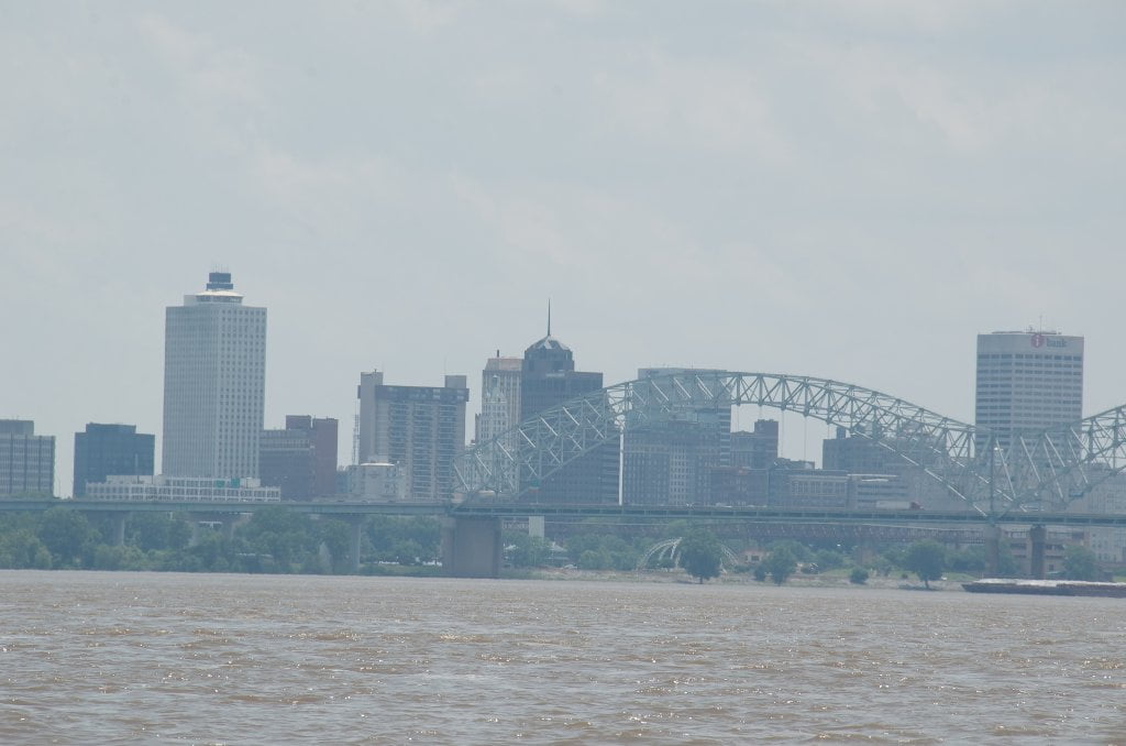
737 Memphis “M” Bridge (Hernando de Soto Bridge)

Now you can enjoy the distinct pleasure of floating under the elegant “M” Bridge.  This beautiful “through arch” bridge was designed symmetrically from center pier in the shape of an eagle or hawk, its wings outstretched and forever soaring above the roiling currents of the Mighty Mississippi River!  You too will feel like you are flying as you soar under the rounded steel arches and dark concrete roadway in your canoe or kayak.  If there is no tow traffic, stay in the fast water through open span river left where the fast water is coursing underneath and you are well positioned for pull out into the Memphis Harbor.  Downstreamers normally choose this same span for the fast water.  In high water upstreamers normally charge under the next span over, the western span (river right west of center pier), but in low water they have to use the eastern span to find enough depth of water.


Completed in 1973 this bridge was originally named the Hernando de Soto Bridge for that explorer, but locals call it simply “M” Bridge or “New Bridge.”   At night, the bridge is illuminated by 200 sodium vapor lights along its M shape structure. The bridge was first lit on September 5, 1986, after $373,000 of private funds had been raised to fund the cost and installation of the lights.  But the lights and their mesmerizing reflections confused towboat pilots so the City of Memphis installed a remote switch to toggle the lights on and off while the vessel passes under the bridge.  During the Great Flood of 2011, the bridge became dark for about 2 months because the transformers that supply the electricity for the lights were removed to prevent damage to them by flood waters. The bridge was re-lit in a ceremony which occurred on June 21, 2011.  Since 2000, the bridge has been under a seismic retrofitting project, which allows it to withstand a 7.7 magnitude earthquake. This is being done since the bridge is located within the New Madrid Earthquake Zone and would not have been able to sustain that magnitude of an earthquake.

Leave A Comment

SECTION MILE ACCESS CITY
Middle Mississippi & Bluegrass Hills / Bootheel 195-0, 954-850 ST. LOUIS TO CARUTHERSVILLE
Chickasaw Bluffs 850 – 737 CARUTHERSVILLE TO MEMPHIS
Introduction  
Caruthersville to Osceola
850 – 737 LBD Options for Paddlers in the Caruthersville Stretch
Above Caruthersville  
Below Caruthersville  
850 RBD Caruthersville Harbor Boat Ramp (1/2 Mile Up Harbor)
849 RBD Mouth of the Carutherville Harbor
849 RBD Trinity Barge Fabrication Plant
847 RBD Blaker Towhead
846.5 Caruthersville
846 RBD Isle of Capri/Lady Luck Casino and Casino Inn Suites
845 – 840 LBD Caruthersville – Linwood Bend
850 RBD – 840 LBD Day Trip: Caruthersville to Booth’s Point
840 LBD Linwood Bend Boat Ramp
839 Caruthersville Bridge
Bridges and Mud: How Deep is the Mississippi Mud  
Several Routes Around Islands 18, 20 and 21  
838 – 835 LBD Island 18 Towhead
829 – 832 RBD Island 20 Dikes and Towhead
823 – 829 LBD Island 21
Routes for the Paddler Around Tamm/Barfield Bends  
820 – 815 RBD Wright’s Point – Tamm Bend
819.3 LBD Mouth of the Obion River
Moss Island WMA  
817.7 LBD Tamm’s Landing and Ed Jones Boat Ramp
817.7 – 801.8 LBD Chickasaw National Wildlife Refuge
No Levee?  
814 LBD Nebraska Landing
815 – 805 LBD Barfield Bend
809.3 RBD Barfield Boat Ramp
806 RBD Tomato Arkansas
805 – 801 RBD Island 25
Paddler’s Options in the Island 30 – Osceola Area  
800 – 796.5 RBD Island 26 and Forked Deer Island 27
803 – 787 RBD Ashport-Keyes Gold Dust
796 – 791 RBD Ashport Gold Dust Dikes
797 LBD Shoaf Landing
797 LBD Lower Forked Deer River
796 LBD Ashport-Keyes Boat Ramp
793 – 785 RBD Island 30
796 LBD Ashport-Keyes Boat Ramp
Neark (Jacksonville) Landing  
786.5 LBD Back Channel Island 30
785 RBD Osceola Arkansas
783.5 RBD Sans Souci Boat Ramp
Osceola to Shelby Forest
785 RBD Osceola Arkansas
783.5 RBD Sans Souci Boat Ramp
782 LBD Driver Island
779.8 LBD Old Mouth of the Forked Deer
779 – 778 LBD First Chickasaw Bluff
Alternate Paddler’s Route Around Hatchie River & 2nd Chickasaw Bluff  
778 – 773 RBD Sunrise Towhead – Island 34
777 – 773.5 LBD Hatchie Towhead
773.5 LBD Mouth of the Hatchie River
773.5 LBD Lower Hatchie National Wildlife Refugee
771 – 772 LBD Angelo Towhead
771 LBD Randolph Landing
771 – 769 LBD The Second Chickasaw Bluff (Richardson Bluff)
768.9 LBD Richardson’s Landing
768 LBD Randolph’s Landing/Duvall’s Boat Ramp
766 – 763 LBD Below Richardson’s Landing Dikes and Bar
Dyess Arkansas, Birthplace of Johnny Cash’s Five Feet High and Rising  
Five Feet High and Rising  
767.6 – 761.5 RBD Island 35
767 RBD Island 35 Boat Ramp
Back Channels of Island 35  
767.6 RBD Entrance
761.5 RBD Exit Behind Dean Isand
Memphis Gage  
Dikes and Water Levels  
Reading Google Maps  
761.5 – 757 RBD Dean Isand
761.5 – 757 RBD Back Channel of Dean Isand
Third Chickasaw Bluff  
758 – 754 LBD Denseford Bar and Dikes/Hen and Chicks
752.7 LBD Shelby Forest Boat Ramp
Shelby Forest to Memphis
Memphis Gage  
Dikes and Water Levels  
752.7 LBD Shelby Forest Boat Ramp
Hen & Chicks Round Trip  
754 – 745 LBD Meeman Shelby Forest State Park
754 – 747.5 RBD Back Channel of Brandywine Island
Buoys and Dikes  
Paddling Into Memphis: Three Distinct Routes  
749 – 742 LBD Hickman Bar
Picknicking and Camping on Hickman  
746 LBD Upper Hickman
745 LBD Middle Hickman
744 LBD Lower Hickman
743 LBD Below Lower Hickman
740.6 LBD Loosahatchie River
743.5 – 740 LBD Redman Point Bar
Memphis Upper Waswater Treatment Plant  
M.C. Stiles Waterwater Treatment Facility  
739 LBD Conoco Lucy-Woodstock Memphis Chemical Terminal Dock
740.6 LBD Wolf River
738.4 LBD Mud Island Upper Boat Ramp
740 – 737.5 Loosahatchie Bar
737.5 Ferry Crossing to Memphis From the Bottom of Loosahatchie Bar
737 Memphis “M” Bridge (Hernando De Soto Bridge)
736 LBD 4th Chickasaw Bluff: Memphis
736 LBD Memphis Mud Island Harbor
Mud Island Riverpark & Museum  
Memphis Yatch Club Marina & Boat Ramp  
Coast Guard Boat Ramp  
Memphis Conveniences Useful to Paddlers  
Several Challenging Round-trips From Memphis  
The Lossahatchie Redman Figure-Eight  
The Loosahatchie Roundtrip  
Hickman Bar Roundtrip  
Upper Delta 737 – 663 MEMPHIS TO HELENA
Middle Delta 663 – 537 HELENA TO GREENVILLE
Lower Delta 537 – 437 GREENVILLE TO VICKSBURG
Loess Bluffs 437 – 225 VICKSBURG TO BATON ROUGE
Atchafalaya River 159 – 0 SIMMESPORT TO MORGAN CITY
Louisiana Delta 229 – 10 BATON ROUGE TO VENICE
Birdsfoot Delta 10 – 0 VENICE TO GULF OF MEXICO