The Lower Mississippi River Water Trail

A rock weir was installed several hundred feet up from the river to hold water in the lake.  The Tunica Runout opens over the weir at 14 feet on the Helena Gauge (HG).  Below 14HG you will have to portage to get to the lake beyond.  Below 0 HG you won’t be able to reach the weir at all by canoe or kayak, but you can dock your vessel at the mouth and walk in.  According to local expert Rick Howe the “top of weir is at about 8 MG or about 14HG and there is notch in the weir about 20 ft wide with base at 6MG or about 12HG.  Same effect as rock dike with water flowing over it….not advised to cross it or enter the notch.  If stable…OK.  Portaging around it is a bugger since banks are really snotty and steep, so only route is over it.  Rocks and concrete can be treacherous.  I’ve never tried it but not sure I would want to.”


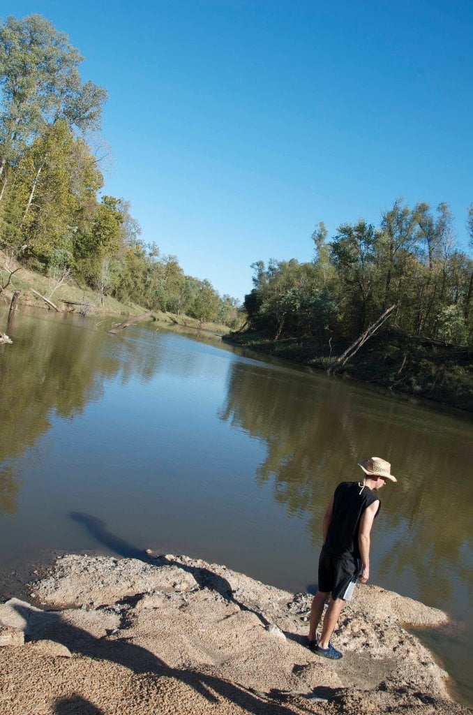
The runout is a dynamic three-and-a-half mile long passage connecting the big river and the giant oxbow Tunica Lake.  As a true pass it can reverse directions depending on river conditions.  In a rising river the water flows in, and in a falling river the opposite.  The faster the change in river level the faster the water responds in the pass.  In extreme river changes (more than 2 feet a day) a strong current can be expected, and sometimes whitewater conditions are found at the weir.  As the river rises above 10 HG the water begins pouring into the lake in a falls over the weir.  By 15 the weir is completely submerged and turbulence can be encountered.  Above 20 the turbulence lessens and by 25 there is smooth laminar flow into the lake.  The reverse is true in a falling river; the water will begin cascading over the weir around 15.  In a fast falling river watch out for a big drop between 10 and 15HG.  Sometimes a challenge to paddle against, these same in-and-out powerful currents keep the Tunica Runout open and free for passage.  Self-dredging.  Self-supportive.  Self sufficient.  Around 35 the river here is bank full and the runout becomes a long channel meandering through a flooded forest, for the paddler an experience bordering on the sublime.  The Runout becomes a vibrant reflecting pool for the trees, the sky and everything contained therein.  On a bad day you will be uplifted, on a good day you might find ecstasy.   Everything seems perfectly balanced between heaven and earth.  The scenery is beautiful and the wildlife spectacular.  There is always something going on.  Numerous game trails cross the pass, predominantly those of the white tailed deer, but also wild hogs, raccoon, and coyotes.  Beaver are common, and river otter sometimes seen.  Black bear are infrequently reported, and there are rumors of cougar, none verified.  But if the elusive red panther is going to be found anywhere in the south, this floodplain this sure feels like the place!  Ditto for the ivory billed woodpecker.  Pileated woodpeckers are frequently seen crossing from side to side, red-headed woodpeckers, and dozens of other bird species.  Red winged blackbirds love the flooded woods closer to the lake, especially during their late fall and early spring migrations, and of course great blue herons and white egrets are common, but to a lesser extent the green heron.  In the colder months giant flocks of white pelicans and double breasted cormorants frequent the open lake beyond the pass along with coot and numerous ducks.

Leave A Comment

SECTION MILE ACCESS CITY
Middle Mississippi & Bluegrass Hills / Bootheel 195-0, 954-850 ST. LOUIS TO CARUTHERSVILLE
Chickasaw Bluffs 850 – 737 CARUTHERSVILLE TO MEMPHIS
Upper Delta 737 – 663 MEMPHIS TO HELENA
Introduction  
Memphis to Tunica
736 LBD Memphis, Tennessee, Mud Island Harbor
Buoys and Docks  
Floating Underneath a Bridge  
734.7 Lower Bridges/Engineer’s Bar
734.7 The Frisco Bridge
734.7 The Harahan Bridge
734.7 The Ghost Bunker
734.7 The Old Bridge (Memphis & Arkansas Bridge)
733 President’s Island
Fleeted Barges  
732 LBD Hole in the Wall ##2
727.3 TVA Transmission Lines
727.3 RBD The Wreck of the Raft
Tennessee Valley Authority  
725.5 LBD Entrance to McKellar Lake
7 Miles Up harbor Riverside Park Marina On McKellar Lake  
724 T.E. Maxon Wastewater Treatement Facility
Paddler’s Routes Below Memphis  
727 – 712 Dismal Point/Ensley Bar/Cow Island Bend Area
726 – 717 Armstrong/Dismal Point/Ensley Bar
720 Josie Harry Bar
718 – 713 Cow Island Bend
Goodbye Tennessee, Hullo Mississippi  
The Yazoo-Mississippi Delta and the Blues  
711 – 705 Cat Island No.50
710.8 LBD Starr Landing
712 – 695 Paddler’s Routes Around Cat Island and the Casinos
Pickett Dikes Back Channel  
639.8 RBD Tunica Riverpark Museum Boat Ramp
Tunica Riverpark Museum  
Basket Bar Dikes/Porter lake Dikes  
693.8 RBD Lost Lake Pass
703 Buck Island (No. 53)
701 Gold Strike Casino
700 Fitzgerald’s Casino
Tunica to Helena
700 Basket Bar
Paddler’s Routes Through Commerce and Mhoon Bends  
695 – 690 Commerce Bend
692.5 RBD Peter’s Boat Ramp
690 Rabbit Island
Switching to thhe Helena Gage  
Dikes and Water Levels  
687.5 Mhoon Landing
689 – 685 Mhoon Bar
690 – 683 Mhoon Bend
682 – 679 Whiskey Chute/Walnut Bend
680 Whitehall Crevasse
Paddler’s Routes Below Walnut Bend  
Stumpy Island, Shoo Fly Bar and Tunica Lake  
Main Channel  
677.4 LBD Tunica Runout
Behind Shoo Fly Bar  
Stumpy Island  
Walnut Bend Boat Ramp  
Tunica Lake Boat Ramp  
679 RBD Walnut Bend Boat Ramp
679 – 677 Hardin Cut-Off
677.4 LBD Pass Into Tunica Lake
677 – 676 Shoo Fly Bar
677 – 674 Stumpy Island
674.5 Harbert Point
672 RBD Mouth of the St. Francis River
Primitive Landing at the Mouth of the St. Francis Rive – Conditions  
RBD 3 Miles up St. Francis River Three Mile Ramp
Daytrip: St. Francis to Helena  
St. Francis to Helena: Paddler’s Descriptions  
For Intermedite Paddlers: Right Bank Route  
For Expert Paddlers: Left Bank Route  
St. Francis River  
671 – 673 LBD St. Francis Bar
669 LBD Flower Lake Dikes
668 RBD (A View of) Crowley’s Ridge D
668-663 RBD Buck Island (Prairie Point Towhead)
665.5 LBD Trotter’s Pass
663 RBD Helena Harbor
Helena Boat Ramps  
663 RBD Helena-West Helena
Quapaw Canoe Company – Helena Outpost  
Helena’s “Low Road” Into St. Francis National Forest  
King Biscuit Blues Festival (2nd Week of October)  
Helena to Friars
661.6 Helena Bridge (Hernando De Soto Bridge – US HWY 49)
663 RBD Leaving Helena Harbor
Fleeted Barges  
Small Towns in Harbors  
Buoys and Other Stationary Objects  
Highlights of Civilization  
Pollution Within the Helena Industrial Reach  
661.6 Helena Bridge (Hernando De Soto Bridge – US HWY 49)
657 LBD  
How to Get Into the Old Entrance of the Yazoo Pass  
LBD: Alternate Route to Vicksburg: Yazoo Pass  
Yazoo Pass Milage  
Rivers & Robert Johnson  
656 LBD East Montezuma Bar
657 – 654 RBD Montezuma Towhead
654.7 LBD Montezuma Landing
Shuttle Route Montezuma to Clarksdale  
652 LBD Friars Point
652.2 LBD Friars Point Landing (Unimproved)
What’s to Come Further Downstream  
Appendix  
Middle Delta 663 – 537 HELENA TO GREENVILLE
Lower Delta 537 – 437 GREENVILLE TO VICKSBURG
Loess Bluffs 437 – 225 VICKSBURG TO BATON ROUGE
Atchafalaya River 159 – 0 SIMMESPORT TO MORGAN CITY
Louisiana Delta 229 – 10 BATON ROUGE TO VENICE
Birdsfoot Delta 10 – 0 VENICE TO GULF OF MEXICO