The Lower Mississippi River Water Trail
24.5 RBD Motto’s Basin
Paddlers looking for an off-channel access can find it West Bank 24.5 RBD at Motto’s Basin, which is a rare protected harbor for mooring miscellaneous commercial-and-recreational small craft. No boat ramp on site, harbor slips only. You’ll find timber bulkhead with solid fill at timber-pile fender extensions forming 15 foot-wide boat slips. Motto’s Basin is operated by Bud’s Boat Rental, whcih is located by land on LA Highway 11, Plaquemines County, Buras, Louisiana 985-534-2225.
24.4 – 23 RBD Ostrica Anchorage
24-23 LBD Neptune Pass
Three openings in rip-rap allow quick exit from storms, waves and wind, and high banks behind might make for good camping.
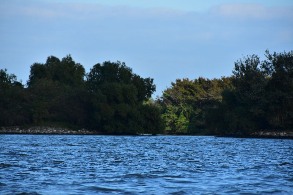
There are three openings around the Neptune Light on the East Bank between 24 and 23 LBD. Paddlers could quickly exit the main channel through any of these small openings to escape wind, waves and storms, and possibly locate low/med camps on the shelves of mud and grass adjacent the passes. The highest banks are through the opening at Neptue 24 RBD. Take your time and pick out the best place. You will discover cleared places perched above the water on muddy shelves, which are sometimes freshly covered with sand, but more often with hardened mud — and topped with grasses and backed by thick vegetation. At low water you will find these mouths protected by lines of rip rap with breaks in the rock which allow water flow – and paddlers – to pass through. Pick your entrance through the deepest opening and enter the protected waters behind. These unintentional man-made harbors are a rare luxury after dramatic experiences with crashing waves along the otherwise unprotected shores and beaches.
22 LBD Bolivar Point
Low/medium water camping, up to 12NO, underwater above that. Best camping is found on the first sandbars located close to main channel on East Bank as you pass mile marker sign 22LBD. This is a beautiful location, with the river making a right angle turn, freighters proudly plowing by, and many sports and commercial fishermen on the water. The sandbars at Bolivar Point would make for great camping if not for all the cattle running around this point and the East Bank shoreline for several miles downstream. If you don’t mind camping around sloppy bovines, amongst their squallering and hollering, and their many poop and pee places, definitely stop here for otherwise good camping (or picnicking). However, if you find it distasteful, go on down to Jackson Point, two miles further downstream, and located on the other side of the river.
We camped on a pile of cattle dung on the last night of a 2009 expedition. We had paddled until sunset, and and then stopped here because it was the only place we could locate in the gathering darkness. This was a decision we later regretted as we first grounded out in shallow mud, and then had to wallow through this mud to reach shore. The final insult was having to strike camp on a high point favored by cattle for the same reason we favored it — high and dry! We resolutely built a fire and set up a big wall tent on the dung pile, and made the best of the situation. But not something I would want to purposefully repeat!
21.4 RBD Protected Industrial Harbor
A long narrow harbor parallel to the flow of the river opens up through the West Bank rip-rap near 21.4 RBD which could suffice for temporary shelter from wind or waves, and maybe picnicking. But you probably wouldn’t want to camp here. Active commercial harbor for small tows servicing local industries. In emergency situations you could pull in and bear right and paddle up to far upstream side of this harbor, where opposite the docking you might find a peaceful spot near a wrecked barge that is sinking into the mud. Bonvillian Marine Boat Rental Service 37772 Hwy 11, Buras, LA 70041, 504-657-6191.
20.9 RBD Lagoons above Fort Jackson
Paddlers will find an opening in the West Bank rip-rap riverbank at 20.9 RBD which leads to two lagoons, and a boat ramp. Excellent location for quick exit offering shelter from waves and wind, and possible locations for an overnight campsite. If the weather is good, however, continue on down to Ft. Jackson Point, which offers a good variety of picnic and camp locations.
20.9 RBD Fort Jackson Boat Ramp
The Fort Jackson Boat Ramp is located at the furthest end of the second lagoon that open up West Bank at 20.9 RBD. This is a primitive gravel boat ramp dropping down from a gravel parking lot on the entrance road to nearby Marine Spill Response Corp, and the Fort Jackson Historic Site. Access via LA Hwy 11 near Triumph.
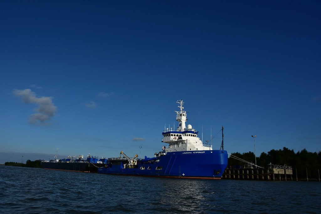
20.8 RBD Marine Spill Response Corp
The ocean-going “Responder-class” oil-skimming vessel Louisiana Responder is docked here except in times of crisis like the Deepwater Horizon disaster, when it becomes a chief player in cleanups. Look for the immaculately-painted bright blue Louisiana Responder as an identifier for Fort Jackson, which sits directly below.
No one wishes for an oil spill. While industry does much to prevent the occurrence of oil spills, the fact is, they do occur. The Marine Spill Response Corporation (MSRC) is a not-for-profit, U.S. Coast Guard Classified Oil Spill Removal Organization (OSRO). MSRC was formed in 1990 to offer oil spill response services and mitigate damage to the environment. MSRC is recognized for its open-ocean and nearshore mechanical recovery capability which includes: 15 Responder Class Oil Spill Response Vessels (OSRVs), 19 Oil Spill Response Barges (OSRBs), 5 PSV Response Packages, 25 X-Band radar and infrared systems, 5 Fast Response Vessels (FRVs), 68 Shallow Water Barges, 650,000 Feet of boom, and 293 Skimming systems. MSRC’s inventory of resources also include other tools for spill response or another emergency. These other capabilities include: In-situ burn, 22,500 Feet of fire boom, Dispersants aircraft and inventory, 6 Dedicated dispersant spray/spotter aircraft, 104,000 Gallons of dispersant, Emergency Communications Services, 7 Emergency Communications Packages (ECP), Support for the Command Center environment, On board generator, Voice and Internet connectivity via Ku-band satellite, WiFi support, VHF/UHF Marine, land mobile, and aviation radio support, VHF/UHF Intrinsically safe land mobile hand held radios, 7 Small Satellite Systems, Support for the small office environment, Voice and Internet connectivity via Ku-band satellite, Air transportable for rapid deployment. (from MSRC website)
Protecting New Orleans:
Building defensive fortifications to protect New Orleans has always been a special challenge to Army engineers. The city has a really unique geography. It is nearly surrounded by water including lakes, the Mississippi River, bayous, marshes and swamps. It was necessary to protect New Orleans, not only from naval forces entering the lakes, but those coming up the river, also. South of New Orleans, two forts were built to accomplish this: Fort Jackson on the West Bank, and Fort St. Philip on the East Bank, opposite Fort Jackson. Together, they commanded the entrance to the Mississippi River.
20.1 LBD – Fort St. Philip
Make landing and look for the remains of the Old Fort St. Philip site (downstream of Bolivar Point). The high ground here would make for great low/med water camping — if not for all the cattle running around this point and the East Bank shoreline for several miles downstream. Oh yeah, and also the muddy landings in low/med water. We camped on a pile of cattle dung on the last night of Brett Roger’s 2009 Old Man River Project Expedition. Hopefully other paddlers avoid this place unless in emergency. Regardless of present condition, Fort Philip plays an defensive role in the development of New Orleans:
Originally built by the Spanish Governor at the same time as Fort Bourbon, Fort St. Phillip (Fort San Felipe) commanded the eastern side of the Mississippi River entrance, and was used through the Civil War. It, like its West Bank counterpart, Fort Jackson, was declared surplus after World War I. Fort St. Phillip is accessible only by boat, because it is several miles south of the end of LA Highway 39, in East Plaquemine Parish.


Leave A Comment
You must be logged in to post a comment.